Indiana's New 3DEP LiDAR Data and Informational Resources
[6/14/2021]
 In December 2020 an initiative to acquire statewide Quality-Level-2 (QL2) Topographic Lidar* covering all of Indiana as part of the USGS 3D Elevation Program (3DEP) was completed. In December 2020 an initiative to acquire statewide Quality-Level-2 (QL2) Topographic Lidar* covering all of Indiana as part of the USGS 3D Elevation Program (3DEP) was completed.
*Topographic Lidar (Light Detection and Ranging) is a surveying method that measures distance to objects using a sensor to illuminate objects on or above the ground surface with laser light, and then measuring the reflected light that returns to the sensor. Differences in laser return times and wavelengths are then be used to make highly accurate 3-D digital representations of the earth.

Applications of Lidar Data
The State of Indiana has a variety of requirements for high quality elevation data. QL2 Lidar is utilized for mission critical activities at all levels of government, academia and private organizations and provides significant cost savings related to utilizing Lidar as a resource. Some of the major use cases identified include:
- Floodplain Mapping, Modeling and Management
- Surface and Ground Water Quality Assessments and Management
- Environmental and Disaster Informatics
- Surveying, Engineering, Transportation and Construction projects
- Homeland Security and Disaster Response
- Geologic Mapping
- Renewable Energy
- Coastal Zone and Maritime Management, Navigation and Safety
- Aviation Navigation and Safety
- Military applications
Acquisition of 3DEP QL2 Lidar in Indiana
3DEP acquisition of QL2 Lidar for the State of Indiana began in spring of 2016 and was completed in the spring of 2020, with the final data delivered in December 2020. This acquisition was accomplished through the following USGS 3DEP BAA initiatives:
In 2015 the Indiana Geographic Information Council (IGIC) submitted a 3DEP BAA proposal to the USGS in partnership with 3 Indiana Counties (Marion, Hamilton and Wayne) to support the acquisition of new Quality Level 2 Lidar data products. This grant was awarded in 2016 and this project was completed in 2019.
In 2016 the Indiana Geographic Information Council (IGIC) submitted a 3DEP BAA proposal to the USGS in partnership with the Indiana office of the USDA – Natural Resource Conservation Service (NRCS) to acquire new Quality Level 2 Lidar data products for 12 Indiana Counties in northeast Indiana. This proposal was selected by the USGS, but before this agreement was finalized the Indiana NRCS office was able to allocate additional funds (totaling $6.625 million), and along with additional 3DEP Federal Funds from the USGS, the original BAA proposal was expanded to collect new 3DEP Lidar data products for all remaining 89 counties in Indiana. This USGS grant was awarded to NRCS in 2017 and this project was completed in December 2020.
Indiana 3DEP Lidar Base Products Include
- Lidar Tiles – individual tiles in LAS 1.4 Format (QL2 Lidar data consists of 2 laser pulses per meter spacing)
- DEM Tiles – individual tiles in IMG Format (Bare-Earth Hydro-Flattened Digital Elevation Model)
- Breaklines – GIS hydrography features (rivers and lake polygons) used to create Bare-Earth Hydro-Flattened DEM
- Intensity Data Tiles – individual tiles in TIF Format (2.5-foot pixel intensity image generated from the First Return Lidar Pulse recording of surface reflectance)
- DEM Mosaic – Merged countywide DEM mosaic file in IMG Format generated from #2 above
- County Delivery Tile Grid – GIS Shapefile showing all delivery tiles and their file names
- FGDC Metadata
This new Lidar data is providing valuable and exciting new elevation products for Indiana that are twice as detailed and twice as accurate as Indiana’s previous 2011 – 2013 statewide Lidar.
With this accomplished, Indiana’s statewide GIS elevation data efforts are now focused on enhanced distribution of this new data, the development of derivative products, and the collection of new bathymetry Lidar data for inland river and stream channels. Read below to learn more about Lidar and for more information on the status of Indiana’s 3DEP Lidar initiatives.
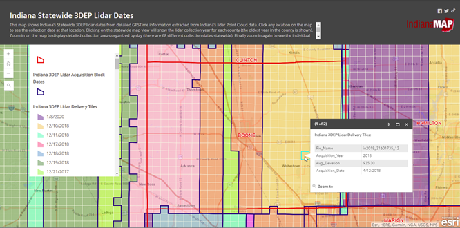
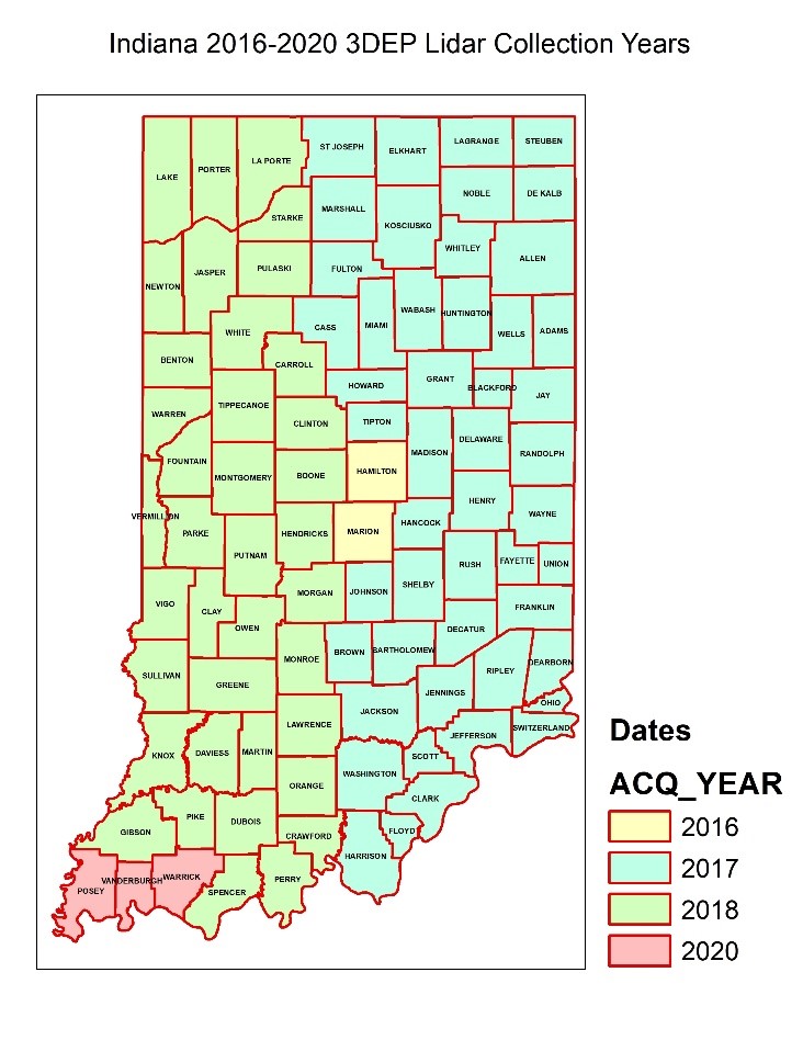
Mapping Indiana’s 3DEP Lidar Collection Dates
Indiana’s Statewide 3DEP QL2 Lidar was collected in the spring over a five-year period (2016 – 2020) on a total of sixty-eight (68) different days. End-users of Indiana’s Lidar data can read the FGDC metadata published for the Lidar data set you are using [here] to see the general collection date information, but reporting the detailed Lidar date information stored in the Lidar point cloud files* provides important more detailed date information. Also, by publishing a detailed map showing these statewide Lidar collection dates, this important information shares and conveys more easily.
* The method used was adapted from the original work - Mapping Lidar Collection Dates from LAS/LAZ Points (wordpress.com) published on February 3, 2014 by Kirk Waters, physical scientist at the NOAA Office for Coastal Management.
For Indiana we used a point thinning method to select and reformat the GPSTime information from each Lidar file and then map the results.
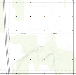 
Indiana Example: Returning a thinned sampling on Lidar Ground Points per Lidar file
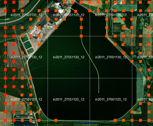
The GPSTime results for each file were combined, summarized and then mapped to show Lidar dates by collection year (for all 92 Indiana counties – see map above), and also by specific file collection dates (for all 41,648 individual files - see example below). An interactive Esri ArcGIS Online Story Map / App was then published to share this detailed date information [here] with all end-users.
Indiana 3DEP Lidar Data – Detailed Collection Dates (example)
Initial Data Distribution
Although the NRCS & USGS did not require any local government or state government funds for this project, the NRCS agreement with USGS still required that all new 3DEP elevation data products be delivered to each County using the State’s existing Ortho-Lidar tiling scheme, and delivered in the appropriate Indiana State Plane East/West Coordinate System for each County. This step is complete, and the map below shows the final results of this effort.
Indiana Statewide Lidar Data Distribution Resources
USGS QL2 Lidar Absolute Vertical Accuracy (3DEP Specifications)
Absolute accuracy is the closeness of a computed value [Lidar point elevation] to its true value [Surveyed GPS Point elevation]. [REF]
| RMSEZ (non-vegetated) |
NVA at 95-percent confidence level |
VVA at the 95th percentile |
| ≤ 0.100 (m) / .328 (ft) |
≤ 0.196 (m) / .643 (ft) |
≤ 0.300 (m) / .984 (ft) |
Based on the table above, you should expect that any elevation you observe in a final QL2 3DEP Lidar or DEM product should be within one (1) foot of its true elevation as measured on the ground, but to assure the absolute vertical accuracy of Indiana’s 3DEP data, a vertical accuracy assessment is performed.
Indiana QL2 Lidar Absolute Vertical Accuracy (Assessment)
Vertical accuracy assessment of the final delivered Lidar data and the derived DEM is a well-established statistical assessment performed following the National Standard for Spatial Data Accuracy (NSSDA). This assessment is performed using well distributed ground surveyed [GPS] check points collected across the entire project area (State of Indiana) in the following major land cover types defined by 3DEP:
- Nonvegetated Areas (NVA) - open terrain, bare earth, urban areas
- Vegetated Vertical Accuracy (VVA) - tall grass, tall weeds, and crops, brush lands and short trees, forested areas and areas covered by trees
Final results of the vertical accuracy assessments for all of Indiana’s QL2 Lidar is published for each Lidar acquisition project in the FGDC Product Metadata files.
QL2 Lidar Vertical Accuracy Assessment for your Area of Interest (AOI)
Indiana’s 3DEP Lidar vertical accuracy assessment is based on a statistical sampling and test performed across the entire State of Indiana. Before you use this data for your project AOI, you need to do your own due-diligence to ensure that the specific data you are using is suitable for your own purposes by performing a NSSDA Vertical Accuracy Assessment of the source Lidar data or DEM in your AOI. Requirements, an overview of this process (site one, site two), and a spreadsheet template to calculate your test results.
Citation for: The 2016-2020 Indiana Statewide 3DEP Lidar Data Products
- Data provided by the U.S. Department of Agriculture, Natural Resource Conservation Service (NRCS), Indiana State Office, and the Indiana Geographic Information Council (IGIC), under separate BAA Agreements in partnership with the United States Geological Services (USGS) 3DEP Program. USGS’s 3DEP acquisition contractor was Woolpert LLC, Dayton Ohio.
- The 3DEP data products are available through the USGS The National Map, the State of Indiana’s GIO Office, IGIC and IndianaMap. 3DEP data products consist of lidar point clouds (LAS) and digital elevation model (DEM) data. All 3DEP products are available, free of charge and without use restrictions
|
 Public - Download